Follow the next phase of our full-time RVing road trip with the interactive maps below. And don’t miss the travel maps from Phase I of our journey to see where Jerry led us during our first two years on the road.
Where have we been?
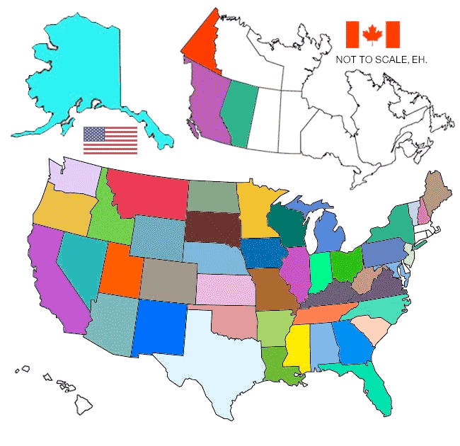
Criteria: Stayed overnight in RV
Create your own RV Visited States Map at visitedstatesmap.com.
Where are we going?
Our Snowbird Phase ended on 2017 when we sold our perfect Colorado summer home. We once again became true full-time RVers with no “Home” base. On the road again full-time, we’ve been workamping and running our businesses from wherever we choose to call home. In the summer of 2023, we sold our fifth wheel and built our a new Project M truck topper camper for the next phase of our Journey. Join us for the ride, and follow along with The Project M Experience! \m/
October, 2024 we purchased our third Arctic Fox ? a 25R travel trailer to haul behind the M. The road goes on forever, but the party never ends…
And now…
The Road Goes on Forever
Fort Collins, Colorado to… (10/24 – ?)
Best Travel Guide Recommendations
Don’t trust the blue dot! We often refer to good old fashioned paper maps and recommend the following guide books to keep traveling safe and easy…
- Gazetteer state atlas travel guides have great detail and include County roads. Read Rene’s Gazetteer review.

- The Next Exit lists services located at USA Interstate highway exits nationwide, including gas, food, lodging, camping, hospitals, and much more.
- The Truckers Atlas is the bible of long hauls drivers, listing truck stops, low clearances, weight restrictions and much more.
- Make the most of any cross-country adventures on America’s two-lane highways with Jamie Jensen’s Road Trip USA
- Fodor’s Essential USA details spectacular cities, natural wonders, and much more to see for the Great American Road Trip.
The Project M Experience!
Fort Collins, Colorado to Willow, Alaska to Los Angeles, California (08/23 – 08/24)
Project M Experience to be continued…
Where To Next?
Fort Collins, Colorado to the Northwest & FOY (11/21 – 05/23)
Full-time Pandemic…
Fort Collins, Colorado to FOY, Sequim, and Back (05/19 – 11/21)
On The Road Again…
Fort Collins, Colorado to Kerrville, Texas and Back (09/18 – 05/19)
See full screen
North! To Alaska…
McCloud, CA to Alaska, to Colorado (04/18 – 09/18)
On The Road Again…
Red Feather Lakes, CO to Mount Shasta, CA (09/17 – 04/18)
Snowbird Season 7
Red Feather Lakes, CO to Big Bend and Back (09/15 – 05/17)
Snowbird Season 6
Red Feather Lakes, CO to So. CA & back with trips to Nashville, TN & Oregon (10/14 – 04/15)
See full screen or create your own.
Snowbird Season 5
Red Feather Lakes, CO to Big Bend and back via Eureka, CA (05/12/13 ? 09/01/14)
Snowbird Season 4
Red Feather Lakes, CO to Fredericksburg, VA and back via Los, Angeles CA (05/18/12 ? 04/06/13)
Snowbird Season 3
Red Feather Lakes, CO and Back via Big Bend, TX (10/17/11 ? 04/10/12)
Snowbird Season 2
Red Feather Lakes, CO and Back via Arizona (10/28/10 ? 05/05/11)
Snowbird Season 1
Red Feather Lakes, CO to Gonzalez, TX and Back (10/23/09 – 05/15/10)
1 thought on “Maps – Phase III”
Comments are closed.